Direct links
Last update: August 22, 2025
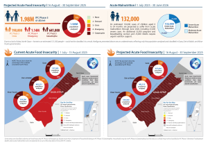
Food security and nutrition conditions in the Gaza Strip have reached critical levels. Recent assessments confirm Famine (IPC Phase 5) in Gaza Governorate as of 15 August 2025. Over 500,000 people are experiencing catastrophic food deprivation, while 1.07 million (54%) are in Emergency (IPC Phase 4) and 396,000 (20%) in Crisis (IPC Phase 3). Between mid-August and late September, Famine is projected to expand to Deir al-Balah and Khan Younis, with nearly 641,000 people (one-third of the population) expected in catastrophic conditions.
Acute malnutrition is rising sharply. By June 2026, at least 132,000 children under five are projected to be acutely malnourished, double May 2025 estimates, including over 41,000 severe cases at heightened risk of mortality. Approximately 55,500 pregnant and breastfeeding women will also require urgent nutrition support. Conditions in North Gaza are likely comparable to or worse than Gaza Governorate, but insufficient data has prevented IPC classification. Rafah Governorate was not assessed due to indications of large-scale displacement.
Nearly the entire population is facing acute food insecurity. Markets remain disrupted, prices are elevated, and coping strategies are increasingly unsustainable. Famine is a race against time. Large-scale, sustained humanitarian access will be essential to deliver food, nutrition, water, and health services and to prevent further loss of life.
Photo credit: Wikimedia Commons
GAZA STRIP: Famine confirmed in Gaza Governorate, projected to expand
The latest IPC analysis confirms that famine is occurring in Gaza Governorate. Nearly the entire population of the Gaza Strip is facing acute food insecurity, with conditions rapidly deteriorating after nearly two years of conflict. Markets remain disrupted, household food stocks are depleted, and humanitarian access is severely constrained. Coping strategies—such as skipping meals, selling essential assets, or relying on unsafe food sources—are increasingly unsustainable.
Between July and September 2025, a large share of households experienced extreme food consumption gaps and widespread malnutrition. Mortality linked to hunger and disease continues to rise, particularly among vulnerable groups, including children, pregnant and lactating women, and the elderly. Displacement, lack of safe water, and destroyed infrastructure are compounding the crisis.
The IPC projects that without immediate, large-scale assistance and secure humanitarian access, conditions will worsen further. While some assistance has reached parts of the population, it remains insufficient relative to the scale of needs. The analysis emphasizes that famine is a race against time: preventing additional deaths requires urgent, unimpeded humanitarian response at scale. Sustained improvements in access, health services, and market functioning are critical to avert further deterioration.

Damaged Agricultural Lands in the Gaza Strip
Gaza Damage Assessment Application
The Gaza Damage Assessment Application is an interactive geospatial tool to provide a detailed visualization of damage in the Gaza Strip. By integrating high-resolution satellite imagery analysis with GIS mapping, this tool enables users to explore destruction patterns and affected infrastructure.
The application presents three core thematic maps, each offering unique insights into the extent of damage:
1. Grouped Damage Map
2. Main Damage Sites Map
3. Damage Status Map